|
|
-- This is the start of Page 11 --
CLICK FOR OTHER PAGES or use TOC/Menu
General: Pg 1, Pg 2, Pg 3,
Pg 4, Pg 5, Pg 6,
Pg 7, Pg 8, Pg 9,
Pg 10,
Pg 11, Pg 12, Pg 13, Pg 14,
Pg 15, Pg 16, Pg 17,
Pg 18

Custom POI: Page
1, Page 2,
Page 3, Page 4, Page 5,
Page 6,
Page 7, Page 8, Page 9

7/8X5
Page 1, 7/8X5 Page 2, 7/8X5
Page 3

Info Page TOC/Menu The Newbie Page
|
BAD EATING INFORMATION FROM MY nüvi
- Techniques For Eating On The Road
Writing on an Internet forum, Robert (not real name) discusses a GPS problem. Robert often drives on highways that have limited access. When he gets
hungry he will query his nüvi for a place to eat via Where to? > POI > Food > All Categories. He laments that his nüvi starts identifying  establishments closest to his position in an every
expanding circle from where his vehicle is located, ahead, right, left, and in back -- BUT -- his closest exit
is still 12 miles ahead and he can't take advantage of any of the eateries that are on the side roads TO WHICH HE CAN'T GET. He was asking, "...Is there somehow, some way to have the GPS be smart enough to realize
that the next Food I can get to is 12 miles away. Rather than showing me 400 Burger Kings 2, 3, 4, 6, 8 miles away..." establishments closest to his position in an every
expanding circle from where his vehicle is located, ahead, right, left, and in back -- BUT -- his closest exit
is still 12 miles ahead and he can't take advantage of any of the eateries that are on the side roads TO WHICH HE CAN'T GET. He was asking, "...Is there somehow, some way to have the GPS be smart enough to realize
that the next Food I can get to is 12 miles away. Rather than showing me 400 Burger Kings 2, 3, 4, 6, 8 miles away..."
Five Possible Techniques For Robert To
Use
(1) The technique (which is the most common technique) that
Robert has used doesn't really assist him in this case since there seems to be so many establishments  near by that he can't get to and, that the
scrolling limit for his listings stops at 52 and that might be way before he approaches the next limited access
highway's exit. Besides he doesn't want to have 'chow-down' places, that are behind him, listed. But the technique
might be suitable if the exit was closer -- so we won't summarily dismiss it. He still wants the identity of the
restaurant way in advance of his arrival. near by that he can't get to and, that the
scrolling limit for his listings stops at 52 and that might be way before he approaches the next limited access
highway's exit. Besides he doesn't want to have 'chow-down' places, that are behind him, listed. But the technique
might be suitable if the exit was closer -- so we won't summarily dismiss it. He still wants the identity of the
restaurant way in advance of his arrival.
(2) Another technique, t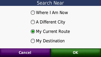 hat many forget about, is that your nüvi (most models -- but you will have to check yours) provide
a technique to list ONLY the establishments that are ON YOUR ROUTE. To activate,
you must have a route already set -- it won't work if you don't. [That stands to reason for your GPSr wants to
know the route you are on before it can suggest only POIs on that route.] Here is how you activate it (in some
nüvis)[Remember a route must first be
set]: hat many forget about, is that your nüvi (most models -- but you will have to check yours) provide
a technique to list ONLY the establishments that are ON YOUR ROUTE. To activate,
you must have a route already set -- it won't work if you don't. [That stands to reason for your GPSr wants to
know the route you are on before it can suggest only POIs on that route.] Here is how you activate it (in some
nüvis)[Remember a route must first be
set]:
Press Menu to get to the Main
Menu > Where To? > Press 'Near' at the bottom of the screen > Select 'My Current Route' > OK > Points
of Interest > Food > All Food
What will appear will be a scrollable window listing 52 eating establishments ON OR NEAR your route. As
you drive the listing will adjust itself.
Interestingly, the listing seems to be limited to those establishments UP AHEAD and doesn't include,
like the first technique does, any behind or those that are very far off route. I don't know,
as of this writing, what distances to either side of your route are included in the identification, but I do know
it is much, much more than the 'mysterious 50 to 75 feet off road' limit that a normal POI has.
If you should select an establishment your nüvi will ask you if you want to set it as a new destination or
a via point. My personal recommendation is to never (well, hardly ever) set it to a via point, for if you do and
decide to go to another eating establish your nüvi will hound you and hound you trying to get you to go the
set via point. [I discuss this in my article "MY VIA DRIVES ME LOCO - Via Point Woes"].
I would set it as a New Destination and later, after eating, at wherever you chose, reset your route to your original
destination. You would find it easily in your 'Recently Found' area.
Robert's problem MIGHT still exist if he is far away from his exit. I personally have been unable to test (I always
like to test with my own equipment before giving definitive instructions.) I am not sure if his unit, with this
setting, will project ahead to his next exit, 12 miles ahead, or will still be picking up establishments near by
his current route to which he is not able to go due to the lack of an exit. I don't have any long highways near
me with spread out exits -- for testing.

(3) I DON'T SUGGEST THAT YOU USE
THIS THIRD TECHNIQUE WHILE YOU ARE DRIVING
as there are an abundance of key presses and that could be dangerous, HOWEVER IT WILL IMMEDIATELY LET YOU KNOW WHAT EATING ESTABLISHMENTS ARE UP AHEAD -- AT YOUR NEXT
EXIT -- so that you can prepare yourself
for 'chowing down', in advance -- if, like Robert, that is what you want. Perhaps, if you have a passenger, they
could do it for you. The technique involves placing the unit in GPS Simulation Mode and then doing a 'Set Loc'
at the next exit.
| [ Note: (March 2011) With some of the newer nüvis, the
white arrow, that you will read about below, has been eliminated. On these models you simply touch the screen at
the 'on the road' position that you want, and a description balloon will usually appear (but sometimes it wont).
Once you have activated a balloon, if you desire to transport your vehicle to that spot, you press the Edit (3
bars, upper left corner of the screen) and select 'Set Location'. ] |
|
We will assume that you are driving with a route set.
- Press 'Menu' > Press 'Stop' [you
need to get out of your route mode to activate the GPS Simulator]
- Tools > Settings > System >
Set GPS Simulator to 'On' > Back (3) to Main Menu
- Press 'View Map' > Touch and Drag
map to 2D display to the next exit (presumably 12 miles ahead. You may have to also adjust your zoom level)
- Touch map at the exit, a white arrow
will appear > Press 'Set Loc.' your vehicle icon will jump to this position > Press 'Back'
- Press 'Menu' > 'Where To?' > Points
of Interest > Food > All Food
A scrolling menu with the nearest restaurants will appear. Select one. DON'T PRESS GO
-- you are in simulation mode and you have moved your vehicle -- it will do you no good. However, you did 'Select
one'. This will register the restaurant in your 'Recently Found' folder (did you know that?).
Now you have to get out of GPS Simulator mode.
- From Main Menu > Tools > Settings
> System > Set GPS Simulator to 'Off' > Back (3) to Main Menu
- Press 'Where To? > 'Recently Found'
> Select the restaurant (it should be at the top) > Press 'Go' > Let your nüvi take you to the restaurant.
Remember, after you finish eating reset the route to your original destination (mentioned in (2) above.)
I told you that there was a lot of activity for this technique, so even though it is the most accurate, it is not
safe for you to be touching your instrument so much while driving. It might cause hair to grow on the palm of your
hand.
(4) You know you are going on such a trip and you might get hungry, so pack sandwiches or carry snacks to tide
you over even if you have  to stop at a 711, Circle K, or WaWa early on your way to load up. Then the 12 miles won't matter. to stop at a 711, Circle K, or WaWa early on your way to load up. Then the 12 miles won't matter.
(5) Tough it out! Remember that there are starving children in China (or there used to be) who could tough it out.
091206


FORCING YOUR NÜVI TO DO IT AGAIN
- A Work Around Recalculation
One user was lamenting the fact that once his nüvi determined a route, unless he strayed off that route and
his device did an automatic recalculation or traffic conditions and his traffic setting were such that his nüvi
automatically did a recalculation for a more appropriate route, he couldn't force a recalculation.
IN THE OLD DAYS --with my Garmin GPSIII+, I could recalculate a route using the Rocker Keypad (buttons on the front).
Later, with my Street Pilot 2610 I could do a recalculation from the Route Menu.
The newer nüvi models don't have a built-in express way of recalculating a route -- but the Work Around is
easy.
We will suppose that you are on a set route to a destination. Depending upon your nüvi model, you can do something
similar to this:

Press Menu > Stop >
Where To? > Recently Added > your destination should be at the top of the listing, select it > Go
You have just forced a recalculation.
091211


IN WHICH DIMENSION ARE YOU?
- 2D/3D Briefly Revisited
One of my early articles* discussed using my nüvi's 2D  or the more modern 3D map viewing ability. At that
time, I was 'up in the air' mostly using 2D. Later I switched to 3D but then vacillated back and forth. or the more modern 3D map viewing ability. At that
time, I was 'up in the air' mostly using 2D. Later I switched to 3D but then vacillated back and forth.
[*See: 2D OR NOT 2D - Personal Preference for
Screen Display]
Most users latch on to the 3D view and never have used 2D, except when their
unit automatically switches during map screen touch and drag, extreme zoom out, turn maps, and show maps.
During the past year, several have written me stating that
they really prefer and use the 2D viewing
giving reasons such as:
With 2D view:
- "...screen redrawing is much faster."
- "...I can see a greatly enhanced
map area and more detail when zoomed in better than I could see with 3D."
- "...and it is easier to find the
magenta track when my Garmin asks me to 'find the highlighted route' when I am starting out from off road areas
such as large parking lots."
- "...since street names that I am
passing have been eliminated from the top of the screen (they were there in my old nüvi) and in 3D view aspect
very little of the intersecting side streets are labeled with their names, I find that the 2D view offers me a
great increase of named side streets, especially when zoomed in more. This feature is important to me as it shows
me the names of the next couple of streets ahead and I am sorry that Garmin removed it, but the 2D viewing is an
acceptable substitute. It is a great boon to me when some vehicle or tree is blocking the view of the street signs
on the corners, when the letters are so tiny, or when the sign is bent or obliterated."
- ...I find it easier to see Custom POIs
displayed on my map screen."
- ....and also I can see my zoom scale
when in the 2D mode. I can't in the 3D mode."
- ...I am so accustomed to looking at
flat maps that the 2D view is better for me."
- ...3D serves no purpose for me when
I am hiking or geocaching."
- "...using my nüvi in an airplane
[as a passenger], keeping it in 3D makes no sense, I have to switch to 2D to enjoy the plane's route."
- "...and when you approach route
turns they display much more quickly in 2D mode rather than 3D."
- ...I'm not sure but I believe that my
touch screen is more accurate when in 2D."
- ...when turns quickly follow one another
such as after ramps and clover leafs I can see them displayed in advance, helping me to make better driving adjustments."
- ...allowing me to see more of my Favorite
icons on the map screen."
- ...with the 2D setting the North indicator
appear in the lower right corner of my nüvi's screen. This does not happen in the 3D setting."
- ...when I get into a driving jam such
as a traffic situation the 2D aspect, giving me a better view of all the roads, is the view I prefer."
- ...I tried using 3D, then switched back
and forth, but now I know I like the 2D display better.
2D or 3D, the preference is yours. Your nüvi's adjustment can be made similar to the following (depending
upon your model).
Tools (Wrench) > Settings
> Map View [choose Track Up(2D), North Up (2D) or 3D]
091216


CAN YOU .WAV WITH LESS FREQUENCY?
- PCM 44.100kHz 16 Bit, Mono Is Only One Setting
Many owners of non-mp3 playing nüvis have learned, either through articles here (*1-5) or from other important WEB sites and sources that they are not step-children when it comes to
having a voice or special  alert coupled with a Custom POI on their GPSrs. alert coupled with a Custom POI on their GPSrs.
The 'trick' is to use a .wav sound in conjunction with the Custom POI and process the two with their POI Loader
program which is accompanied by a special file, 'sox.exe', that also resides in the folder with POI Loader.
Owners of nüvis with .mp3 capabilities often use the .wav files in the same manner for voice alerts in order
to squelch the dreaded '.mp3
song skip' that seems to happen for those listening
to .mp3 songs while driving at the very instant after a .mp3 voice or sound alert plays.
Details of the above can be found
in the references (*1-5).
Now Garmin, at least on their web site in the POI Loader section and using their main search engine and the support
search engine, does not tell you about the possible use of .wav files and the 'sox.exe' file. In fact they only
mention .mp3 audio files (not .wav). Garmin: "You can attach .mp3 audio files to your Custom POIs. You can also create TourGuide
points that include .mp3 files containing audio descriptions of the POIs. The .mp3 audio file plays instead of
the default alert tone on your compatible Garmin device when you approach a POI."
So, one is left to think that non .mp3 playing nüvis can only have the default 'bong' and 'ping' alerts with
Custom POIs. Of course, with the 'sox.exe' work around, this
is not true.
Anyway, it is also a common belief that when one uses a .wav file for alert purposes it must be of the format:
PCM 44.100kHz 16 Bit, Mono -- which does work.
When I have used a .wav file for this purpose I have followed that format. Sometimes I would have to make adjustments
to achieve that format while preparing my own voice or sound or ones that I have downloaded from the Internet using
such programs as Win dow's
Sound Recorder or Audacity which have that capability
of adjusting formats. dow's
Sound Recorder or Audacity which have that capability
of adjusting formats.
NOW, THE REST OF THE STORY
The above was just background build-up to reach this point.
The other day while attempting to help a nüvi 1490T user, I was preparing a voice sound file. I often visit
the AT&T Labs Research Page
[http://www2.research.att.com/~ttsweb/tts/demo.php] which has a neat little on-line program that allows you to type in a message and it will prepare
a voice .wav file for you, with a choice of several speakers -- both male and female. These .wav files can be used
by POI Loader as alert messages for your Custom POIs.
For some reason, after I downloaded the file I produced to my computer, I used the 'Right Click/Properties' feature
of Windows Explorer and was surprised to find this:
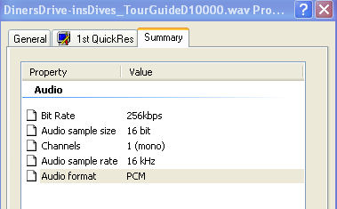
Notice that the Audio sample rate was different than what
I previous thought was required (PCM 44.100kHz 16 Bit, Mono) it is: PCM 16kHz 16 Bit, Mono; and
IT WORKED as a voice sound when tested with my nüvi.
The size of the @16kHz file, in this case, was 99 KB. If this file were to be converted to the @44.100kHz size
it expands to 273 KB using Sound Recorder and 271 KB using Audacity
-- almost three times the size of the @16kHz file.
CONCLUSIONS
The frequency rate of a .wav sound file used in the preparation of a voice alert for Custom POIs does not have to be @44.100kHz. It can be @16kHz or possibily
other frequencies. There are too many to
test-- so I didn't. I just want to raise the possibility for your future actions in this matter.
Also, using alternate frequencies can reduce or expand the size  of the.wav file -- if that is important to you. of the.wav file -- if that is important to you.
I feel good now. I have just solved the World's problems. When does that Nobel committee meet again?

REFERENCES
(*1) DON'T MAKE A .WAV - Now nüvi Series 200 Can Have Music,
Sound & Voice Alerts
(*2) RUN
SILENT -- RUN NO-PEEP - Silent and Semi-Silent Alerts
(*3) THE
'PROXEMICS' OF THE TourGuide - Hakuna Matata! The Circle Of ... Alert
(*4) THE POI'S THE THING - Seeing Custom POIs At Various Zooms --
Yes You Can!
(*5) ALERT! GEOCACHE POINT NEAR - On And Off-Road Geocache Point
Alerts With Map Icons For nüvis
091217


NAUGH-T, NAUGH-T, COORDINATES
- A Couple Of Coordinate Games
There are a number of coordinate games that people play using their GPSrs the major one being 'Geocaching' where
people world wide hide and seek caches (little treasures). I won't talk about that at the moment but if you have
an interest an excellent site to check out would be Geocaching - The Official Global GPS Cache Hunt Site at http://www.geocaching.com/. I do have a number of articles that mention Geocaching
and your nüvi here on this web site. Use the search engine to find them.
There is a much smaller group of individuals who seem to be interested in taking themselves to intersecting longitude
and latitude georeference coordinates where the values of each are WHOLE NUMBERS WHICH END IN NAUGHT (ZERO).
For example the intersection of 0 degrees longitude and 0 degr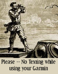 ees latitude is on the Equator (which is considered 0 degrees latitude) directly
on the longitudinal coordinate known as the Greenwich Meridian Line (or the Prime Meridian of the World) which
was established in 1884 at the International Meridian Conference. Before that time there were a changing number
of established meridian lines -- causing the Garmin Company to have to constantly up date their hardware and software
for their customers. Those of you who owned the Garmin Sextant Mdl. 1240 in the early 1880s know what I am talking
about. ees latitude is on the Equator (which is considered 0 degrees latitude) directly
on the longitudinal coordinate known as the Greenwich Meridian Line (or the Prime Meridian of the World) which
was established in 1884 at the International Meridian Conference. Before that time there were a changing number
of established meridian lines -- causing the Garmin Company to have to constantly up date their hardware and software
for their customers. Those of you who owned the Garmin Sextant Mdl. 1240 in the early 1880s know what I am talking
about.
 Let us say that you wanted
to be at longitude 0, latitude 0, just to brag about it to your Facebook friends. You would have to travel by ship
to a point about 380 miles (611 kilometers) south of Ghana and 670 miles (1078 kilometers) west of Gabon -- not
an easy task in your Sevylor inflatable kayak. Let us say that you wanted
to be at longitude 0, latitude 0, just to brag about it to your Facebook friends. You would have to travel by ship
to a point about 380 miles (611 kilometers) south of Ghana and 670 miles (1078 kilometers) west of Gabon -- not
an easy task in your Sevylor inflatable kayak.
On our globe there are some 614 individual
locations where the longitude and latitude coordinates are WHOLE NUMBERS ENDING IN
'0'. Most of these are over
water and ice. But there are a number over land that some seek out -- just for the experience and bragging rights.
As big as the continental United States is, there are only 7 such locations located over land (over water doesn't
count.)
| Longitude |
Latitude |
Comments |
| W90 |
N30 |
Just outside of New Orleans, Louisiana |
| W100 |
N30 |
About 100 miles NW of San Antonio, Texas |
| W80 |
N40 |
Right in the heart of Fredericktown,
Pennsylvania in the SW corner of the state. |
| W90 |
N40 |
Near Newmansville, Illinois about 23 miles
NW of Springfield, Illinois |
| W100 |
N40 |
On the Nebraska/Kansas border 215 miles NW
of Wichita, Kansas |
| W110 |
N40 |
In the Utah mountains 90 miles E of Provo,
Utah. On the Ouray Indian Reservation |
| W120 |
N40 |
Inside the California border with Nevada about
6 miles from Doyle, California, and 34 miles from Reno, Nevada |
You might try going to one or more of those
7 georeference spots using your GPS. By car or on foot, some are easy to get to, or at least get very close to.
But for now, why not just try and find the seven of them using the 'Coordinate' function of your nüvi?
From the Main Menu: Where
To? > Scroll down and select Coordinates > Enter a set of one of the 7 pairs that I listed above > Next
> Map > Zoom in and out to get a lay of the land and to see if it is a place that you could visit by car
or foot (are there any roads in the area?)
Now do the other 6.
It is interesting to note that while the Prime Meridian passes through England, that that country doesn't have
a single X0/X0 longitude/latitude georeference combination as I have been discussing. Neither does Ireland, the
Netherlands, Belgium, Fr ance,
Switzerland, Italy, Portugal, Luxembourg, Austria, Denmark, Sweden, Finland, etc. However Germany and Spain (just
by the skin of its shore) have one each. Norway has one and almost has two more -- but those two are over water
between islands. The big winner is Canada which has a slew of them - Eh!. Seattle has a Slew too -- but now I'm
just horsing around. Hmm, bad joke. That's like putting the horse before the Cartesian. ance,
Switzerland, Italy, Portugal, Luxembourg, Austria, Denmark, Sweden, Finland, etc. However Germany and Spain (just
by the skin of its shore) have one each. Norway has one and almost has two more -- but those two are over water
between islands. The big winner is Canada which has a slew of them - Eh!. Seattle has a Slew too -- but now I'm
just horsing around. Hmm, bad joke. That's like putting the horse before the Cartesian.
EASY GAME FOR YOU
We will ignore the naughts and will now
allow all whole numbers for this close by exercise for you.
QUEST: Try and visit the corners of your home's Geo-Box (rectangle) designated by its whole number longitude/latitude coordinates.
Where ever you live you are bounded by a Geo-Box governed by longitude and latitude coordinate intersections of
whole numbers.
For example, if you live at W94.798998,
N38.855224. You would be in the
Geo-Box who's corners are:
W95, N39
W95, N38
W94, N38
W94, N39
Notice we are using whole
numbers.
Your task would be to visit each of those coordinates
(or as close as possible considering private property rights and bodies of water.)
Your home, in this example, is already close to one of those corners (W95, N39).
In effect, any home (within the continental United States), will never be more than about 46 straight line miles from the nearest whole number Geo-Box corner, and most of the time, much, much less. Once you are at a corner, going North or South to the next corner would be a straight
line journey of about 69 miles. Going East or West to a next corner in the continental
United States is a different story. The distance will vary based upon your latitude but it is safe to say it would
approximate between 44-62 miles.
Residents of some homes, such as those near the coasts, will not be able to visit all four corners. Homes near
our country's border 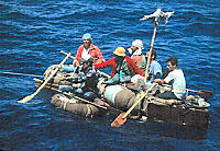 may
require passports to enable you to touch base in adjacent foreign countries with all your locations. Also, some
southern Florida residents will not be able to visit any of the corners unless they use boats. But in Florida,
everyone owns a boat so -- no problem. If the Cuban refugees can do it, you can too. may
require passports to enable you to touch base in adjacent foreign countries with all your locations. Also, some
southern Florida residents will not be able to visit any of the corners unless they use boats. But in Florida,
everyone owns a boat so -- no problem. If the Cuban refugees can do it, you can too.
ANOTHER
Have Fun!
100104


FOLDERING YOUR MP3S ON YOUR NÜVI
- A Work Around To Let You Prepare Mixes Of Tunes And Play Them
Reader Sue Dö-Nim (Gardena, California) writes that she wants to pr epare specific mixes of various types of
.mp3 music and be able to play them on her .mp3 capable nüvi while she is driving -- like she can do on her
Ipod. epare specific mixes of various types of
.mp3 music and be able to play them on her .mp3 capable nüvi while she is driving -- like she can do on her
Ipod.
She remarks that when she adds the folders for these mixes to her SC/HDSC card her nüvi just grabs the songs
and places them in a giant listing making her unable to extract the particular mix she is seeking. Explaining that
she has prepared a folder of music from the 80s and another folder of music from the 90s, each with songs of various
genres such as rock, blues, country, world, jazz, hip-hop, etc., relating to that period. Sue says that she CAN
use this folder mix with her I-pod and other .mp3 players, but that she can't with her nüvi.
At this point most sages would tell her that her Garmin will take all her .mp3s, from from the SD card, and put
them all in one big listing. This list CAN be delimited by All / Album / Artist / Genre by the Garmin, all based upon the .mp3 ID Tag information imbedded in the music files. 'All', 'Artist' and 'Album' give you an appropriate alphabetical listing, but 'Genre' will also break down song listings by
a number of different imbedded tags that may or may not be included in the original file. Her mixes will be listed according to their .mp3 tags and not by
their folder position. Therefore what she
exactly wants, can't be done.
Well, I am not a sage, so it is OK for me to show you an easy Work Around that will accomplish what Sue wants.
We will take advantage of the 'genre' tag to do this. Remember in Sue's folders of the 1980s and the 1990s she
has a mix of genres for her tunes in each of the folders. What we are going to do is to give all the songs in the
folder the same genre ID tag -- in one case 'My1980' and in the other case 'My1990'. You are
making your own CUSTOM genre tags -- name it what you will.
First, Create a Folder on your hard drive and call it (suggestion) 'My1980'.
Copy (don't move) ALL the .mp3 files that will belong, to this folder. The reason you
want to copy is so that you don't change the original file in its original position in any way. If you have need
for more separate mixes, then create additional folders.
You can accomplish the renaming of the genres with a variety of available programs -- some of which you may have on your computer right now, but let me suggest a FREE and very easy to operate program --
Stamp ID3 Tag Editor (Stamp
Mp3 Tag Editor) available at: http://www.nch.com.au/tageditor/index.html.
Go get this program and place it on your hard drive. You will receive the setup program 'stampsetup.exe'
which you should run to install the actual program. Do what you want about the menu for additional features, but
for the purpose of this project I didn't select any.
Now run your newly established 'stamp.exe' (it
will probably already be open as a result of the setup procedure.) For future reference it will be (most
probably) in "C:\Program Files\NCH Swift
Sound\Stamp\stamp.exe". There may also be a shortcut icon on your desktop that will run it when you want.
Using the menu on the left (not the Browse button) find and click the new folder 'My1980' and its songs will appear
in the large window on the right. Click in that window and do a CTRL-A to Select All.
If there is anything in the 'Genre' box, highlight it and delete it. Now type in "My1980" as the Genre
[of course this will change for different folders.] You are creating your own CUSTOM genre tag. You don't
ONLY have to choose those suggested in the pull down box.

Now when you click the button 'Stamp' at the bottom of the
page, All songs in the upper window will be marked with the Genre "My1980". You will see a green time
line as this is happening.

The entire re-tagging process will take less than 30 seconds
once you get used to it.
Close the program and now send your folder 'My1980' to the
SD/HCSD card of your nüvi via the USB connection. [We
are using the card here because often, when a lot of .mp3 files are sent directly to your nüvi, the memory
will fill up. Using the card gives you more room for your .mp3 files.] The folder and it's files will be sent to your nüvi's card.
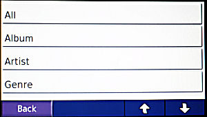
When you later activate your Garmin nüvi and navigate to your .mp3 player (there are various techniques of doing this depending upon your model), select 'Browse' (at
the bottom) then 'Genre' (below left graphic).
 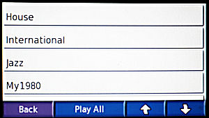
A screen (above right graphic) will appear
and you then scroll down, if necessary, to 'My1980' and select it. That's your music mix of the 1980s.
If you have more folders to do just repeat most of the above
steps. You'll already have the Stamp program.
Many times when you download music, the genre marking
may not be what you were expecting. For example Zydeco music is often classified as zydeco or international or
world or blues or country or Cajun or etc. This presents quite a 'genre' confusion to your Garmin when attempting
to play your Zydeco music via just the Genre choice. On most of your .mp3 players you can place music in folders
which can contain a mix of genres and all the music in the folder will play. Not so with your Garmin .mp3 player.
This Work Around technique will solve Sue's and your problem.
The above technique will somewhat mimic the Folder technique of an .mp3 player and you will receive the results
you want.
This article was actually predicated upon
an e-mail question by Jan Janowski (Skokie, Illinois) who wanted a system of separating
his Rock and Jazz .mp3 items. He did not know that the 'genre' keys for his collections were all over the place
and not just in the Rock and Jazz categories. My above contrived story shows how you can have a mix of various
assigned 'genres' and change them to a common 'assigned genre' so they all can appear together at selection time.
Jan could also use the technique to make sure that all his 'Rock' is marked rock (genre) and all his 'Jazz' is
marked jazz (genre).
100117


BATTERY LOW?
- How To Replace The Internal Battery On A Garmin Nüvi
Appearing today in a sister publication, GPS Magazine, is one of
the best articles I have seen about replacing a nuvi battery. It is complete with details and excellent photos.
A writer named FLETCH, who I don't believe is related to Chevy Chase, takes the credit and is to be applauded for
his efforts.
You can read the article at on the GPS Magazine Web Site by clicking
this link.
[Bob Cohen of Washington told me about the
article]
100217
April 19, 2010
Several readers have written advising of sources for Garmin replacement batteries.
http://www.newpower99.com/SearchResults.asp?Search=nuvi&Search.x=13&Search.y=16
http://www.batteryship.com/htmlos/htmlos.cgi/34327.5.248687732010252042
http://www.batterybay.net/Garmin-GPS-Battery-s/332.htm
Personally, I have not had any experience with these suppliers so I am not making any recommendations. You might
do a Google, Bing, or Yahoo (etc.) search for "Garmin Batteries" to discover additional suppliers.


|