|
|
-- This is the start of Page 13 --
CLICK FOR OTHER PAGES or use TOC/Menu
General: Pg
1, Pg 2,
Pg 3, Pg 4, Pg 5,
Pg 6, Pg 7, Pg 8,
Pg 9, Pg 10,
Pg 11, Pg 12,
Pg 13, Pg 14, Pg 15, Pg 16,
Pg 17, Pg 18

Custom POI: Page
1, Page 2,
Page 3, Page 4, Page 5,
Page 6,
Page 7, Page 8, Page 9
7/8X5
Page 1, 7/8X5 Page 2, 7/8X5
Page 3
Info Page TOC/Menu The Newbie Page
|

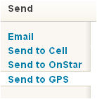
MAPQUEST DROPS SENDING LOCATION TO YOUR NÜVI
- Is This Temporary? [YES]
August 1, 2011 I just received an e-mail from Curtis (FNU) who advised that MapQuest no longer
allows you to send a location or a route to your GPS, as it once did.
LATER
August 5, 2011 - Curtis just
advised that MapQuest had just reinstated the option of sending locations and routes to your GPS back into its
Classic Version, even adding a Send to OnStar link -- but has not done this with the new mQ site.
STILL LATER
August 29, 2011 - Curtis just advised
that MapQuest had just included the ability to send locations in its new mQ site and appears
to have completely dropped its classic version.
Trying to link to mapquest.com currently opens new.mapquest.com.
|
[ I will wait a month to see how things stabilize
and then make necessary revisions or re-writes.]
=====
After a little checking, this is what I discovered (August 1, 2010).
On June 29, 2010 MapQuest did a major revision (they are still not through) of their mapping program. Part of which
was to launch a new second web site named  at http://new.mapquest.com/ still maintaining their former MapQuest site at http://mapquest.com -- which they now refer to as MapQuest Classic.
Features of the new site are at FEATURES
There is even a short video about the site at VIDEO
What has happened is that the ability
to send a location and a route from MapQuest to your GPS is not currently included -- but might be in the future.
See MapQuest announcement of this fact.
It also claims that one could still use
MapQuest Classic to send a location and a route to your GPS -- but (currently) one CAN'T -- it is NOT enabled in MapQuest Classic. [It now is -- see note at top]
There are some other current MapQuest documents published on the announcement date that state that you still CAN
accomplish the 'sending' task:
WHAT DOES THIS MEAN TO YOU?
CURRENTLY you can't
send, from MapQuest, locations or routes to your nüvi. [You now can
send locations and routes to your GPS using the Classic version of MapQuest -- see note at top]
- Some articles written on this Garmin Nüvi Tricks WEB
site concerning MapQuest and sending locations and routes to your nüvi are currently not valid
[they are valid again -- see note at top],
as you can't currently use the technique. I have placed a notice at the top of each of these article alerting readers
that the MapQuest procedure is not currently available.
- I'm guessing, but I think that the feature will be reinstituted
at a later date -- especially if the fan base writes MapQuest or complains about it on social networks such as
Twitter [http://twitter.com] and Facebook [http://facebook.com] etc. [It has been reinstituted in the Classic version -- see note at top]
- You can STILL use Google Maps [http://maps.google.com] and Bing Maps [http://www.bing.com/maps/] to send locations to your nüvi GPS -- so all is not lost.
- I will wait until MapQuest finishes making
their changes and either update or re-write articles pertaining to using MapQuest (both the Classic and mQ versions) for sending locations and routes to your Garmin.
[ I will wait a month to see how things stabilize
and then make necessary revisions or re-writes.]
100802
100805
100829

MY TWO ROUTES TO JAPAN ON MY NÜVI
- Straight and Great Circle (Previously Undiscovered Feature)

Here is something interesting
that you might want to play with. I have to tell you that IT DOESN'T work with my nüvi 755T, but it MAY, as
it does with Jack's nüvi 255WT, work with more modern nüvis.
Jack Eiferman of Massachusetts writes,
My nüvi (265WT) has a world map built in, even though it came only with USA maps. One accesses it by going
into GPS Simulation mode (Tools
> Settings > System > GPS Simulator On > OK)
and zooming out a lot, then doing a bit of dragging. It's quite a good map, with a fair amount of detail (other
than roads, though it does have major highways) with all major cities that I checked, no villages. Not bad at all.
If I put the unit into Off Road & Pedestrian Modes it'll give me the distance between any two spots on the
globe -- sort of.
For Off Road Mode: Tools > Settings > Navigation > Route Preference
> Off Road > OK
For Pedestrian Mode: Tools > Settings > System > Usage Mode
> Pedestrian > OK
For example, Hagi Japan is in my Favorites (it's a long story) and Hagi is listed as being 6961 miles from my home
in Brookline MA. I told my nüvi to "Go!" there, and the green screen on Go! says 8557 miles.
[Ed: when you search for a Favorite
your nüvi presents a straight line distance, but when you activate the Go! (normally in the 'On Road' mode)
it presents its figured Road mileage.]
Now here comes the cool part: The route is drawn with TWO
(2) lines - one is a straight line and the
other a circular route, that is so circular it's a semi-circle (as far north as over Alaska). What is going on?
Is the circular route a 'Great Circle' route? Anyway,
here's a pic (my screen doesn't quite show the entire circle, but you will get the idea). Very cool!
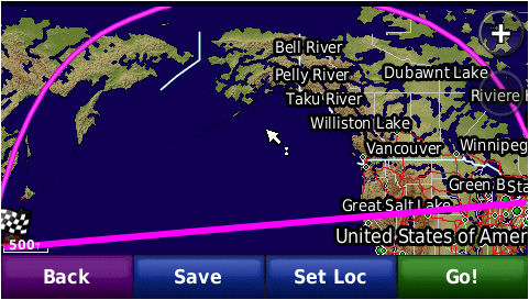
[Ed: I'm going to take a WAG
and opine that the 6961 milage relates to the Great Circle route distance, while the 8557 is what the nuvi thinks is a straight off road path. Mr. Mercator called and wants 1596 miles back.]

[Sep, 2010 - John Zinn writes that he tested the WAG with the UK site -- Movable Type - "Calculate distance, bearing and more between
Latitude and Longitude points"
and his results were the same as the pictured map. The site is highly technical but does contain entry data points
that allow you to insert latitude and longitude (and other information) values to produce a variety of results
-- including maps. Check it out.]
100828
100908
IS YOUR HOME A GPS TARGET?
You Had Better Watch Out
Kenneth Berkstresser wrote me with a concern stating that those who leave their units in their cars and have identified
their houses as their 'HOME' may have a problem if their units get stolen fro m the their cars. m the their cars.
Kenneth says, "Having Home
set in your GPS is a road map for those would be thieves to find your house. If they pilfer your unit while you're
at the ball game or some other relatively long duration event, they not only know where you live, they also know
you're gone and when you'll return. Even worse, if they steal your vehicle with the unit in it and you have the
door opener to your attached garage [inside].
"Around my house, people are taking their kids to ice rinks for hockey games [Kenneth is from Canada] and their practices
were targeted. Thieves know they'll have a good two hours before the theft of a vehicle is discovered. Using the
GPS Home function means little time is wasted by these thieves in finding their targets."
Kenneth is correct. So, what should you do? Here are a couple of suggestions from Kenneth and myself that may aid
you in this matter:
- Don't use your house as your HOME setting.
This can help eliminate the problem. If yo
 u want you can select an intersection several blocks away from your house and call that HOME.
Let that point be close enough so that you can use it when you determining distances to and from your house, but
far enough away so that your house can't be identified. You should, by now, know how to drive from that nearby
point to your house. Of course, if you live way out in the Boonies or own a house in the Hamptons, miles from anyone,
that won't work very well -- because you're the only house around. u want you can select an intersection several blocks away from your house and call that HOME.
Let that point be close enough so that you can use it when you determining distances to and from your house, but
far enough away so that your house can't be identified. You should, by now, know how to drive from that nearby
point to your house. Of course, if you live way out in the Boonies or own a house in the Hamptons, miles from anyone,
that won't work very well -- because you're the only house around.
- Activate your lock on your Garmin. [HIGHLY SUGGESTED
 ]. That way, if the thief gets hold of it, he(she) won't be able to turn it on without knowing the code.
However, he may find other information in your car which identifies where your house is located, and if you use
your house or the front of your house as your 'lock setting point' your Garmin will now start working for him and
he can easily reset the code. So ... never use your house as a location where you set your code. What I do is drive
to the front steps of one of my local police stations and set my code there. Very rarely will a thief go to the
police station to try and activate a Garmin, and, of course, he won't be able to activate it in front of my house. ]. That way, if the thief gets hold of it, he(she) won't be able to turn it on without knowing the code.
However, he may find other information in your car which identifies where your house is located, and if you use
your house or the front of your house as your 'lock setting point' your Garmin will now start working for him and
he can easily reset the code. So ... never use your house as a location where you set your code. What I do is drive
to the front steps of one of my local police stations and set my code there. Very rarely will a thief go to the
police station to try and activate a Garmin, and, of course, he won't be able to activate it in front of my house.
- Don't set your HOME at all! Instead, make
your Home a Favorite and give it a code name so that it can appear early in your Favorites list. Perhaps something
like 'AAA Office7' so when you need to go home from a distant place all you have to do is find that special Favorite
and let your Garmin guide you.
- It's a nüvi. It
 's small. It's easy to remove from the bracket
and take with you whenever you leave your car. [ALSO HIGHLY SUGGESTED].
That way if a thief breaks into an unattended car, he will never find your nüvi and will NOT be able to use
it to find your Home. Also, as a side benefit, you will always have your nüvi with you to help you find your
car when you are returning. [I lose my car all the time in large parking lots because it always ends up between
two gigantic SUVs, where I can't see it.] 's small. It's easy to remove from the bracket
and take with you whenever you leave your car. [ALSO HIGHLY SUGGESTED].
That way if a thief breaks into an unattended car, he will never find your nüvi and will NOT be able to use
it to find your Home. Also, as a side benefit, you will always have your nüvi with you to help you find your
car when you are returning. [I lose my car all the time in large parking lots because it always ends up between
two gigantic SUVs, where I can't see it.]
-
- If a thief doesn't see your GPS inside
your vehicle, he is less likely to break-in.
For more information about making an info
Splash Screen, you might again want to look at:
OLYMPIC
GOLD MAKES A BIG SPLASH ON THE NÜVI - A Simple Splash Screen For Lost/Stolen Nüvis
on page 5.
By the way, this article
was written using Nuance's new Dragon NaturallySpeaking 11 voice dictation software (Home Edition). Read about
it here: http://www.nuance.com/talk/. I like it and recommend it.
100929
SOME IDIOSYNCRASIES OF CITYXPLORER MAPS
- Slightly Confusing?
Please note, at this time I do not have a GPS which incorporates
the use of a cityXplorer map -- but I should have one in the near future. So be advised that I have NOT
personally worked [which I normally do] with such a map feature and am unaware of its pluses and minuses.
Garmin nüvi models that can use cityXplorer maps with advanced pedestrian navigation include: series 1100, 1200, 1300, 1400, 1600, 2200, 2300, 3700. Some other nüvi models may
be able to use cityXplorer maps but limited applicability. |
Rick Sparber writes concerning his experience with cityXplorer maps. Some of the newer model Garmin nüvis
have the ability to use these maps, mainly for pedestrian applications over and above what the normal Garmin maps
provide.
Garmin sez:
cityXplorer Maps
cityXplorer maps for your street navigator provide the latest
detailed roads and points of interest for metropolitan areas, plus enhanced pedestrian navigation street
directions including public transportation.
With cityXplorer map data, you can conveniently download information about your destination directly to your Garmin
device. Confidently navigate using the same mapping detail as City Navigator® maps. -- snip --
Enhanced pedestrian navigation helps you navigate the city's public transit. Get directions for where to walk,
where to catch the bus, subway, tram, or other transportation (where available). Also learn how long it will take
to get there. In some cities, data is even available for transit schedules, such as subway or bus times and routes.
From Rick Sparber:
I am a long time user of GPS and am on my second nüvi. Yet I was initially very confused with how my nüvi
operates with the cityXplorer map. Rather than have my present location stay on the screen and the map move below
it, cityXplorer requires you to manually move the map by advancing along the path.
This is the second cityXplorer I have bought. My first one was for Philadelphia and I never did understand what
it was doing. We didn't walk much so my experience was limited. My second cityXplorer was for the Bay Area and
I tried to use it many times during our visit.
Operation is vastly different than a normal moving map GPS. You start by selecting a destination. It then offers
you one or more routes involving walking and public transportation. After making your selection, you begin the
trip. The process involves reading the directions for the  next leg at the top of the screen, arriving at the next way point, and then manually
advancing the text to guide you to the next way point. As the text advances, so does the map. next leg at the top of the screen, arriving at the next way point, and then manually
advancing the text to guide you to the next way point. As the text advances, so does the map.
If you make a mistake, your present position icon can vanishes from the screen yet the path can remain. Mistakes
include bumping the screen and initially moving in the wrong direction. Furthermore, since reception can be poor
in urban canyons, accuracy can be low. The nüvi puts a circle around your location icon to show accuracy.
The problem is that this circle can encompass a large area so I found myself walking in the correct direction on
the correct street yet the nüvi showed me walking away from the street through a building. If you don't keep
an eye on this icon, it can fall off the screen and leave you looking at just the path. On more than one occasion I was fooled into thinking
I was still on route when in fact I was going the wrong way. one occasion I was fooled into thinking
I was still on route when in fact I was going the wrong way.
As for calculated path options, I had one experience where I could get to my destination via cable car or a bus
on a parallel street. The only route offered was for the cable car. The wait to ride the cable car was around 1
hour so I wanted to use the bus. It was then that I realized that the free public transit map given to me at the
hotel was far more useful than the nüvi. I used this simple map for the rest of our vacation.
So if you are comfortable with the moving map display functionality of the nüvi with base maps, be aware that
the cityXplorer is a completely different animal. I won't be buying any more of these maps unless they do a far
better job of integrating it into the nüvi.
101115
NEW 3790LMT NOW BEING USED FOR TESTING
- Garmin Continues To Make Changes In Newer Models
It wasn't Christmas, but it felt like it.
The other day I received my new Garmin nüvi 3790LMT. I had been interested in this new model, a Cnet Editor's
Choice, ever since it 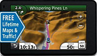 appeared,
but I was waiting till the price dropped a little, which it did, before I replaced my nüvi 755T with this
much newer whizz-bang model. appeared,
but I was waiting till the price dropped a little, which it did, before I replaced my nüvi 755T with this
much newer whizz-bang model.
I am a believer that as more States are concerned with and are writing laws governing the use of hand held devices
(phones -- calling and texting), it wouldn't be long before screen touching of a GPS while driving would be an
object of concern.
Anyway, the quick report is that I like this Voice Control model and will begin writing articles
presenting you with Tips, Tricks, Work Arounds,
Hints, Secrets & Ideas that I, and you,
develop. I have already seen a bunch of changes.
Although the writings will be directed
toward the 3700 series nüvi models (for
that is what I will use to perform personal testing) many of the findings may be pertinent to all newer models (since the 800 series). So, if you have a newer, 200, 1200, 1300, 1400, 1600, 2200, 2300, 2400 series unit you may want to read (or at least - skim)
these articles as the tips might also apply to the very model that you own -- even though it may not be from the
3700 series.
Some of my  older
articles will still apply to nüvis across the board, but with Garmin's operational changes in each model it
releases, prior directions may need to be altered to accomplish a task. Not having those models at my disposal,
as always, I will need, and appreciate, you advising me via e-mail of the changes required for your particular
model so that I can add notes to older article or completely re-write them if necessary. You should include step
by step information in a language that a novice can understand and follow. older
articles will still apply to nüvis across the board, but with Garmin's operational changes in each model it
releases, prior directions may need to be altered to accomplish a task. Not having those models at my disposal,
as always, I will need, and appreciate, you advising me via e-mail of the changes required for your particular
model so that I can add notes to older article or completely re-write them if necessary. You should include step
by step information in a language that a novice can understand and follow.
Look for articles to appear here in about two weeks.
Your editor, Gary Hayman
110131

|