|
|
-- This is the start of Page 5 --
CLICK FOR OTHER PAGES or use TOC/Menu
General: Pg
1, Pg 2,
Pg 3, Pg 4, Pg 5, Pg 6, Pg
7, Pg 8,
Pg 9, Pg 10,
Pg 11 , Pg 12, Pg 13,
Pg 14, Pg 15, Pg 16,
Pg 17, Pg 18

Custom POI: Page
1, Page 2,
Page 3, Page 4, Page 5,
Page 6,
Page 7, Page 8, Page 9
7/8X5 Page 1, 7/8X5 Page 2, 7/8X5 Page 3
Info Page
TOC/Menu
The
Newbie Page
|
USING THE NUVI TO DISPLAY INDEX CARDS
- Novel Trip Information Display Aid
by contributing writer Mike Epstein, California
My nüvi 750 accepts pictures as direct downloads from
my computer. Since pictures really mean images, you can build and download any image(s) as a picture and display
it on your LCD.
- Open a word processor I use MS Word
- Set the page size, font and font size I use 14 point
Antigua bold, page size 6.0 wide, 3.4 high, no margins. This will allow 14 lines per card.
- Build the text to display
- Copy the text file to an imagery editor I use IRFanView
which can be downloaded for free.
- Save the image as a jpeg file using a pixel size that is
the same as the nüvi device for a nüvi 750 its 480 X 209 .
- Load it into the Garmin device from your computer.
After viewing the image on the Garmin LCD, determine how to play around with the font type and size to get a viewable
image that works for your eyes and application.
Editor's Notes: The Program IRFanView mentioned above can
be obtained from http://www.irfanview.com/.
Most normal Graphics programs WONT accept text files, so if you don't have the suggested file you might
do one of the following:
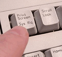
- Prepare your text first (you can even use NotePad), then
use your built in Screen Capture capability (your Prt
Scrn key {Print Screen}) to send the screen
to the clipboard then later paste the resultant graphic into your Graphics program and make the necessary adjustments
there before sending the cropped and sized .jpg of the text (converted to graphics) to your Garmin. Here is additional
information: For XP, For Vista,
For Mac OS-X, Nice
Article.
- Use a screen section snip program. I use the free Snippy (one of my most used and favorite programs). Some might use the
commercial Snagit.
- If you use Vista OS then there is a built in snipping tool.
See Article here.
Author Mike Epstein uses the pixel dimensions of 480 x 209 for these JPGS. I use 480 x 212. I tested both and I
can't see the difference. These dimensions are for the wide screen nüvi units. For non-wide screen units,
I'm guessing (I can't test) that the dimensions would be around 320 x 180. Please note that these dimensions are
dif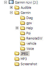 ferent
from the 'splash screen' size of your nüvi where the wide screen units are 480 x 272 and the non-wide screen
units are 320 x 240 pixels. Reason: When displaying JPGS with Picture Viewer there is a 60 pixel area
at the bottom of the screen that is reserved for Garmin display information. Splash screens don't have that information
bar, so therefore can be bigger. ferent
from the 'splash screen' size of your nüvi where the wide screen units are 480 x 272 and the non-wide screen
units are 320 x 240 pixels. Reason: When displaying JPGS with Picture Viewer there is a 60 pixel area
at the bottom of the screen that is reserved for Garmin display information. Splash screens don't have that information
bar, so therefore can be bigger.
Your JPGS can be loaded via your computer to two
places. To the device itself into the JPEG
folder OR directly to your removable SD/SDHC card at root level; not into any folder.
Please don't be confused by the pixel dimension size that the author is suggesting. JPEGs of almost any size can
be stored in your nüvi. However very large dimension sizes are wasteful and take up valuable storage. Your
Picture Viewer will automatically take your JPEG and re-size it KEEPING THE SAME ASPECT RATIO
and display it on a screen area (for wide screen nüvis) of 480 x 212 pixels (less for non-wide screen.) If
your original JPEG isn't that size, a black border on the sides will appear causing your resized photo to be thumbnailish
(I made that word up.) What the author has done here is to cleverly utilize all of the available portion of the screen to display the graphic of the text, so it WONT be resized -- smaller.
This make it easier to read. Kudos.
Added: August 20, 2008
From: GadgetGuy(bgateson2)
I read your new article about creating notecards. I'd like to point out that folks can also create .jpg notes using
Paint. Paint is included in XP and I believe Vista. Start/All Programs/Accessories/Paint.
Open Paint, select Image, then Attributes and change it to 480 x 212. Then select the Text icon and create a text
box over the entire space and type your message in your font of choice. Save the finished product as a .jpg to
the JPEG folder of your device or to your SD/SDHC card. |
|


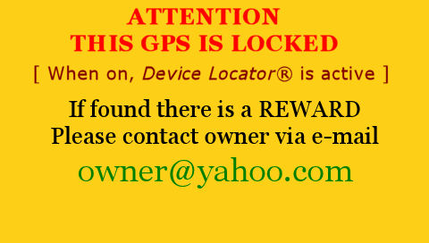
OLYMPIC GOLD MAKES A BIG SPLASH ON THE NÜVI
- A Simple Splash Screen For Lost/Stolen Nüvis
[Note: I am told that because of a the
new design this technique doesn't work on the nüvi 880 model (no reports from other 8XX models) but that the
technique DOES WORK VERY
WELL on models from the
other nüvi series - 2XX, 3XX, 6XX, 7XX.]
ATTENTION 7x5T series owners.You will
use a slightly different setting and technique as far as image size. SEE:
7X5T
SPLASH SCREEN SIZE - There Is A Difference in the 7X5 area. There I furnish you with a splash screen
that will match your units. |
Your nüvi may be misplaced, lost or stolen -- bummer!
Some 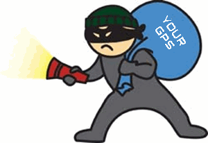 say that the
chance of getting it back might be slim. GPSrs are popular target items for the snatch and grab thefts of opportunity. say that the
chance of getting it back might be slim. GPSrs are popular target items for the snatch and grab thefts of opportunity.
I am sure, by now, that you have heard the warnings of not leaving your unit in a parked vehicle; hiding the device's
support -- be it suction cup, bean bag (which I use) or vent hanger -- from obvious sight; and making sure your
windscreen doesn't have telltale marks from removed suction cups.
You are also probably aware that you should record the serial number of your unit perhaps not only on a wallet
information card but maybe in a text file in your Garmin folder. The number will be highly important for identification
at a later time should your unit be located on the street, at a pawn shop, in a bad guy's cache, in a dumpster,
or maybe on e-Bay or Craig's List.
Another line of defense is to use Garmin's LOCK setting. This will generally prevent others from activating your
device when it is out of your hands.  Please
make sure that you 'set' your lock at a place other
than at your home. It is too easy for shady
people who know about the lock to determine your address from papers in your car, including telephone numbers,
and drive to your abode in the dead of night and unlock your unit. Make it tough on them by choosing a locking
place that is not at your home, office, parking lot, parking garage or any place where you regularly park your
vehicle. Make sure you chose a location that is not likely to be visited by a thief -- perhaps the entrance of
the local police station, which they tend to avoid. Please
make sure that you 'set' your lock at a place other
than at your home. It is too easy for shady
people who know about the lock to determine your address from papers in your car, including telephone numbers,
and drive to your abode in the dead of night and unlock your unit. Make it tough on them by choosing a locking
place that is not at your home, office, parking lot, parking garage or any place where you regularly park your
vehicle. Make sure you chose a location that is not likely to be visited by a thief -- perhaps the entrance of
the local police station, which they tend to avoid.
You may have important addresses stored in your GPS that you don't want anyone to know about.
Quick, erase that Favorite or Custom POI of (lon)
-119.67081, (lat) 39.21858.
Some people recommend the commercial StuffBak http://www.stuffbak.com/ to
help in returns by Good Samaritans.
ANYWAY
With your LOCK established it is a good idea to have a Special
Splash Screen show when your unit is turned
on. This will alert the thief and potential buyer of your purloined unit that there will be difficulty with the
unit. It may not help you get it back but at least you can "chortle in your joy"
knowing that the thief may not make any money out of a potential sale -- 'cause the thing won't work. However,
if a Good Samaritan is in possession of your unit it makes it easier for you to be contacted. I don't recommend
using your name and phone number on the Splash Screen.
> Let's make a simple Splash Screen using Microsoft Paint. (You can use other graphic
programs (they may even be easier if you are accustomed to them) too to create the screen.
Part 1 (Composing and Saving Your Splash Screen)
- Open Paint at Start > All Programs > Accessories
> Paint
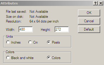
- Select File > New then Attributes (from the Image tab)
and change the size to 480 x 272 for wide screen and 320 x 240 for non-wide screens
(I'm guessing at the last number as I am unable to test) [See graphic for other settings]
- Choose your background color -- perhaps yellow, or if you
like Olympic Gold then try (253, 208, 23)/#FDD017 [use color tab] and Fill the area
with the color
- Switch your color to what ever text color you want and
Activate Text mode, and choose your font,
- Compose your Splash Screen message [See suggestion]
Part 2 (Installing Splash Screen)
[Also see 760 note below]
Wrench > Display > Splash
Screen/Change > Select view Images From Internal Storage (unless you stored your image on the SD/SDHC card)
> Scroll and Select proper image > answer Yes to "Do you want to save this  image as your
splash screen" > Back (2) image as your
splash screen" > Back (2)
Congratulations! "O frabjous day! Callooh!
Callay!" You can now go stand at the
top of the podium with your Olympic
Gold Medal Splash Screen.
If you want to test it out, go to a busy corner
in your town and place your unit on the sidewalk and walk away. If someone picks it up and you eventually get an
e-mail message stating that they have it -- the process works.
[Some quotes from Lewis Carroll's famous poem
"The Jabberwocky".]
[760
NOTE: Frank Tabor writes that the procedure
for his 760 unit is slightly different (perhaps for the entire 7XX series). Once his prepared .jpg is loaded on
his unit the steps for making it a splash screen is as follows - From the Main Menu: Wrench > Picture Viewer > Tap the picture; In the upper
left corner is a check-box to Display at Power on? Touch that box > Back out.]
HAS YOUR NUVI BEEN DISCONTINUED?
- Oh Where, Oh Where Did My nüvi Go?
You woke up this morning
And your nüvi was gone
You just bought your Garmin
Something must be wrong
(sung to the music of the Sopranos theme
song)
Has this happened to you too? Your nüvi GPS is now suddenly listed by Garmin as being discontinued.
The growing list now includes the following nüvi models: 350, 360, 370, 600, 610, 650, 660, 670. Of course, that was 5 minutes ago and things might have changed since then. If
you want to check it out yourself go to https://buy.garmin.com/shop/shop.do?cID=164 to see the discontinued list. Be aware that some
have found that there may be a lag from when a unit leaves the Current Model List (https://buy.garmin.com/shop/shop.do?cID=134) till when it appears on the Discontinued List.
Has the world come to an end for you? Not really.
Many of those discontinued models are still available from retailers, and, if their specifications meet your needs
and the reduced prices are to your liking then, if you are a prospective buyer, they might be a good purchase.
If you are already an owner you can still receive Garmin support and even firmware updates for some discontinued
models; the 600 series is an example. Your nüvi won't stop working just because Garmin has discontinued it
-- without telling you -- even if you bought it last week.
To be fair, the company is developing new models in order to install recent developments and keep competitive in
the ever expanding GPS market -- as well it should. [There are approximately 60 manufacturers of GPS units that
are available in the US.] The competition is pushing hard with its innovations and pricing. Actually, the best
GPS would probably be a combination of features from many of the manufactures.
Garmin, itself, has recently released information about it's soon to be available nüvi 2x5T and 7x5T series (265T, 265WT, 275T, 755T, 765T, 775T, 785T) which will have a variety of new features.
Many have criticized Garmin for having too many choices making it confusing a nd difficult for new prospective buyers to choose which
model is 'right' for them and have suggested that Garmin just have 10 or so models making the choice easier for
the buyer and the retailer who most probably can't stock all current models for their customers. Presently [Oct 2009] there are 28 nüvi models and that doesn't count the 22 discontinued models that may still be available at the retail level -- many are. nd difficult for new prospective buyers to choose which
model is 'right' for them and have suggested that Garmin just have 10 or so models making the choice easier for
the buyer and the retailer who most probably can't stock all current models for their customers. Presently [Oct 2009] there are 28 nüvi models and that doesn't count the 22 discontinued models that may still be available at the retail level -- many are.
I'm not sure that any model is 'right' for you. From my personal experience and the reports from others, once you
purchase your first GPS, and no matter how good it is and how many bells and whistles it has, within a short time
you develop an insatiable 'GPS envy'. I'm on my 5th GPS unit with my anticipating eyes on my next one.

FUTURE OF AUTOMOTIVE GPS
[Some items on listing already
exist and some are down the line]
GPS development will be exciting. New features and new ideas are being developed daily.
- --Avoid pending accidents by recognizing
and alerting for vehicle proximity
- --Traffic light color recognition screen
display and your unit can even alert you to stop car if about to unlawfully violate or are about to violate a red
light
- --Black Box type information technology
for accident documentation
- --Advanced Lane Guidance guides you to the
proper lane of multi-lane roads or to proper turning lanes
- --Real time map updates
- --Driving habit learning modes
- --Unit tracking technology for fleet use
or stolen device location
- --Heads up windshield display (HUD) -- just
like the fighter pilots
- --Posted road speed display and current
traffic speed display of a distant point
- --Road sign detail displayed
- --Historical road data input for better
trip planning and current guidance
- --Suggested best route detours based upon
current traffic speed
- --Vehicle to vehicle speed information (unit
to unit information trade)
- --Building outlines and 3D building views
- -- Integrated camera that displays real time video with
navigation overlays
- --Rolling Internet WiFi and cellular connection
for 2-way information transfer
- --Automatic pothole and obstacle instantaneous
reporting (car to car)
- --Preventing 'run off the road' accidents
- --Automatic car steering
- --Essential part of the Auto Matrix - "...The
Auto Matrix is Cars talking to cars, talking to roads, talking to traffic control centers, The World Wide Vehicle
Web...." iautomatrix.com
- --Many more ...
CONCLUSION

So if your unit has been discontinued -- Don't
Worry. Be Happy. Use it. It
is still good and will do what you purchased it for. Then, wait (at least a week) until you are really ready to replace it with another GPS that you 'must have' and either give
your old GPS away, trade it, or sell it. Spread your old GPSs around, like I have had to.
I GAVE A NUVI AS A GIFT TO MY 16 YEAR OLD.
REALLY?
- A GPS Gift to a Young New Driver
Recently a father posted a message on a GPS forum of how he took advantage of a special promotion being offered
by a credit card company of a FREE nüvi 200 with the opening of an account. He signed up with the express
idea of giving the device to his sixteen year old daughter as a birthday present and as a celebration of her obtaining
her drivers licence.
He was immediately pummeled with a plethora of critical postings which advised, in essence, that it is a very BAD IDEA
to give such an item to a young new driver, stating that the extra distraction that the unit might provide would
be dangerous to that level of driving maturity.
They cited that there are already too many distractions for the driver, what with the driving itself; radio; CD
or iPod music; cell phone use; texting; eating and drinking; and conversations with passengers.
One stated that "...if you love your
daughter and want to keep her alive, you would take back the GPS until she has proven she is a responsible driver
and understands how distractions can kill and is ready to drive safely...."
Another echoed that another distraction is not needed and she should be concentrating on learning to drive.
I am in agreement. Here are three quick finds on the Internet which discuss teen accident rates. Sixteen year olds
are at a very high risk rate.
National Teen Driving Statistics
per http://www.rmiia.org/Auto/Teens/Teen_Driving_Statistics.htm
- Motor vehicle crashes are the leading cause of death for
teenagers.
- 16 year-olds have higher crash rates than drivers of any
other age.
- 16-year-olds are three times more likely to die in a motor
vehicle crash than the average of all drivers.
- 3,490 drivers age 15-20 died in car crashes in 2006, up
slightly from 2005.
- Drivers age 15-20 accounted for 12.9 percent of all the
drivers involved in fatal crashes and 16 percent of all the drivers involved in police-reported crashes in 2006.
- The National Highway Traffic Safety Administration (NHTSA)
estimates the economic impact of auto accidents involving 15-20 year old drivers is over $40 billion.
- A recent report by AAA estimates the cost of crashes involving
15-17 year olds to be $34 billion.
- Graduated drivers license programs appear to be making
a difference. Fatal crashes involving 15- to 20-year olds in 2005 were down 6.5 percent from 7,979 in 1995, to
the lowest level in ten years.
- Fewer 16-year-olds are driving. In 2006 only 30 percent
of 16-year-olds had their driver's licenses compared to 40% in 1998 according to the Federal Highway Administration.
- According to a 2005 survey of 1,000 people ages 15 and
17, conducted by the Allstate Foundation
- More than half (56 percent) of young drivers use cell phones
while driving,
- 69 percent said that they speed to keep up with traffic
- 64 percent said they speed to go through a yellow light.
- 47 percent said that passengers sometimes distract them.
- Nearly half said they believed that most crashes involving
teens result from drunk driving.
- 31 percent of teen drivers killed in 2006 had been drinking,
according to NHTSA. 25 percent had a blood alcohol concentration of .08 or higher.
- Statistics show that 16 and 17-year-old driver death rates
increase with each additional passenger (IIHS).
Teenage Driver Facts:
per http://www.car-accidents.com/teen-car-accidents.html
Deaths. Each Year over 5,000 teens ages 16 to 20 Die due to Fatal injuries caused Car accidents. About
400,000 drivers age 16 to 20 will be seriously injured.
Risks. The risk of being involved in a car accident the highest for drivers aged 16- to 19-year-olds than
it is for any other age group. For each mile driven, teen drivers ages 16 to 19 are about four times more likely
than other drivers to crash.
Stats. Teenagers are about 10 percent of the US Population but account for 12 percent all Fatal Car Crashes.
Costs. Drivers (both male and female) under age 24 account for 30% - $26 billion Dollars of the total
costs of Car accidents in the US.
Sobering Stats
per http://editorial.autos.msn.com/article.aspx?cp-documentid=498409
- According to an analysis conducted for AAA, in 2006 drivers
ages 15 to 17 were involved in approximately 974,000 crashes that injured 406,427 people and killed 2,541. Here
are more sobering statistics:
- According for The Centers for Disease Control and Prevention
(CDC), motor vehicle crashes are the leading cause of death among U.S. teens, accounting for 36 percent of all
deaths in the age group.
- The risk of motor vehicle crashes is higher among 16-to-19-year-olds
than among any other age group, and per-miles-driven teens ages 16 to 19 are four times more likely than older
drivers to crash, says the Insurance Institute for Highway Safety (IIHS).
- Risk is highest at age 16, and the crash rate per miles
driven is twice as high for 16 year olds as it is for 18 and 19 year olds, according to the IIHS.
- IIHS statistics show that 16- and 17-year-old driver death
rates increase with each additional passenger.
- According to teensafety.com, 1 in 3 teenage drivers has
an accident in the first year of receiving a license, and a teenager is injured in a car crash every 55 seconds
and killed every 6.5 minutes.
THE WHITE SOLUTION FOR THE GOOGLE per-PLEX
- Another Technique For Sending Google Locations To Your nüvi
| August 2, 2010 -- Be advised that
MapQuest has recently revised their programs and CURRENTLY they do not permit sending locations or routes directly
to your nüvi. In the meantime, you can still use Google Maps and Bing Maps. Hopefully the technique will be
re-instated in the future. See my article of explanation HERE. |
When Google Maps changed their system earlier this year
the Garmin user, who could formerly send coordinates straight from the Map to their Garmin device as a FAVORITE,
using Google and the Garmin Communicator Plugin, became limited to only Google searches for businesses, addresses, locations and places of
interest -- sending coordinates didn't [seem to] work anymore -- leaving one perplexed.
The technique was covered in previous article:
IMPORTING FAVORITES
FROM GOOGLE/MAPQUEST INTO YOUR NÜVI - 'How To' Techniques For On-Line Imports
Even when using the new developer tools or mapplets discussed
in:
NEW GOOGLE MAPS
WAY OF GETTING LAT/LON COORDINATES - Developer Tools or Mapplets of Great Aid -- the coordinates appeared that they couldn't be directly sent.
This, as mentioned above, meant that if one wanted to send
a Google Map location that Google didn't develop
through the normal search to your FAVORITES
via Garmin Communicator Plugin -- maybe you wanted to move the spot for some reason -- you couldn't do that directly
(or so it seemed.) This was because Google would no
longer present you with the necessary 'GPS'
choice on it's menu when you attempted to do a 'Send.'
The longer Work Around was to obtain the coordinates from
the map and enter them by hand into your nüvi and save the location as a FAVORITE. Not too difficult but there
was a little typing involved.
Latitude and Longitude coordinates are highly useful when
a 'normal' Google search identifies a point in 'the wrong place' or where one has to place the point in a different
position than what was presented during a search. For example, instead of a building in a shopping mall one might
really need the point where the driveway meets the road or perhaps a special entrance to a large park which Google
doesn't identify as the 'entrance of choice.' Or, maybe, as in the below example, you wanted to identify a kayak
launching platform that someone told you about in distant Columbus, Ohio. This point does not have an address nor
is it located on a road.
There are many more reasons. All which would have to be done by hand ...
The Kevin White Work Around Method
Reader Kevin White of Lexington, KY wrote me and revealed his interesting and useful technique for sending Google
Maps generated coordinates directly through Garmin Communicator Plugin to his nüvi 200
device (it will work on other nüvis too.) His solution forces Google to present the missing 'GPS' choice and from then on everything works as normal.
Many thanks to Kevin. I have taken his technique and worked
it into an example to give you an idea as how to accomplish it -- with pictures. At the end, there is a briefer
explanation as a summary.
First we will assume that your nüvi is connected to your computer via the Garmin USB cable and that you are
on-line with your computer. Also that you have Garmin Communicator Plugin installed and working. (See earlier article)
1) Go to http://maps.google.com
2) Go to the 'area' of your spot either by a normal search or moving the map. [If the place is of a distance from
where you are at you could do a search on a city to arrive at the general area.]
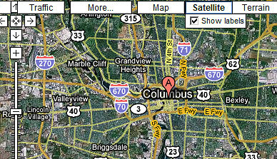
Let's say we did a normal search on 'Columbus,
OH'

This map would appear.
3) Using the zoom capability and street and/or satellite views find the location that you want to identify. In
most cases, it is best to have the spot located on a road as your Garmin performs
'on-road' guidance directions better -- but it doesn't have to be.
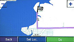
We are going to choose a point at a river launching site to the West of the A flag. It will not
be on a road -- but because it is not on the road, in this case (not all cases), it will later cause a problem
which we will solve with another technique -- good training for today, October 12, 2008, the real anniversary of Columbus Day (Juilian calendar)
4) Mark the location -- zoom in first for accuracy. An easy way of marking is to right click the map at the location
and select 'Directions From Here'. This will cause a new 'A' flag to appear. Hopefully you were very accurate as to where
you placed your cursor before you 'right clicked.'
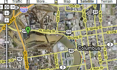
Zoomed in view
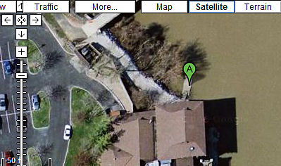
Notice, I'm right on the dock -- not on a road. That parking lot on the left as well as most of the complex is
also not on a Garmin identified road -- keep
that thought in mind; till the end.
5) Now click the 'Send' link

6) Highlight the latitude/longitude coordinates that appear
in the big message box and copy to your clipboard. Now press the Cancel button.
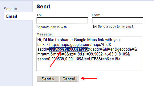
[NOTE: Although,
in this case, the coordinates also appeared at the left hand side of your screen before the initial 'Send' was
clicked, this will not always happen (a street name or 'unnamed road' could appear), therefore I am presenting
a technique that will always work.]
| Please note that the coordinates presented by Google are in
the convention of latitude first then longitude. This is OK for hand entering coordinates
into your nuvi but if later you plan to use Custom POIs you must use the convention longitude first then latitude
when preparing them. But, when you use the above technique, having the 'Send' transfer the information to your
nuvi's Favorites, they get automatically reversed. |
7) Paste the latitude/longitude coordinates in the Google
Search box and press 'Search Maps'.
 
8) When the map gets updated press 'Send'
This time your needed 'GPS' choice will appear
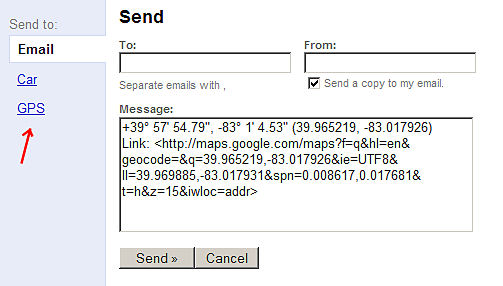
9) Click 'GPS' for a new window
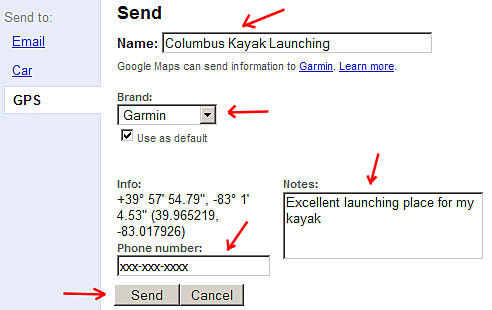
10) In this window, Change 'Name' if you desire, Choose Garmin from the pull down menu if not already presented,
add Notes and Phone Number if you desire. Select 'Send' (from this new window)
[Please note that I am only making up this kayak launching location. I have no direct knowledge if you can launch a kayak
from this point or not. I do not know if the Nina, Pinta, and Santa Maria ever docked here -- so don't ask.]
11) You will now be transported to the Garmin Communicator
Plugin Page
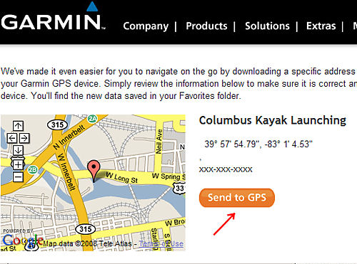
12) Click 'Send to GPS' and the Columbus Kayak Launching will be saved as a Favorite to your nüvi device.
THE TECHNIQUE IN BRIEF
- Go to Google Maps
- Locate your selected point and right click
it
- Select 'Send' then copy latitude and longitude
coordinates
- Paste them in the normal 'Search Maps'
box and activate
- Select 'Send' again and this time your
'Send to GPS' choice will appear
- Make necessary text changes and then 'Send'
it, arrive at Garmin Communicator Plugin, and 'Send to GPS' from there.
You will have placed the location among your Favorites on
your device.
BTW -- a Googolplex [note
that the spelling is slightly different] is a
very, very, very, very ... large number -- 10^[(10)^100] or 10 raised to the googol power; where a googol is the
number 1 with 100 zeros after it.
Googleplex - the complex that houses Google's company Headquarters.
THE OTHER PROBLEM
Remember, we chose a location that was not on a road. Well
when your Garmin later tries to navigate to that point it will take you to the nearest road location that it knows
and then draws a straight line to that point. Often, this will generally work for you as in the case of my fishing
hole articles:
GONE FISHIN BY A SHADY WADY
POOL - - Ye Ol Fishing Hole -- A Place You Know
GONE FISHIN' INSTEAD OF
JUST A- WISHIN' - Ye New Fishin' Hole -- You've Never Been There
In this case, however, your Garmin will probably take you to a point on Dublin Rd. (US 33) that is on a road
and close to your chosen point, and then draw a straight line to the launch site. Unfortunately, the straight
line crosses the open water of the Scioto River -- across which, at that point, drive you cannot (I sound like
Yoda. My ears are smaller.)
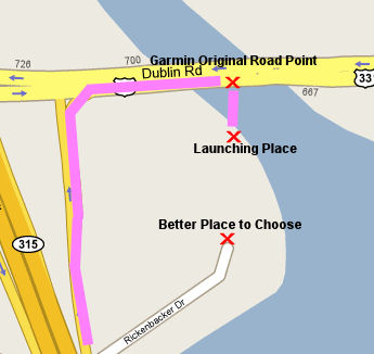
Perhaps it would be better to choose being on a road that
leads to the complex where the launching platform is. This would be at the end of Rickenbacker Dr. (39.964802,-83.01839).
So here, using a combination of Google Satellite AND Map views pays dividends when selecting your coordinates.
As we are now finished with this topic it
is time to say "Goodbye, Columbus."
|