|
|
-- This is the start of Page 1 --
CLICK FOR OTHER PAGES or use TOC/Menu
General: Pg 1, Pg
2, Pg 3,
Pg 4, Pg 5, Pg 6,
Pg 7, Pg 8, Pg 9,
Pg 10,
Pg 11, Pg 12,
Pg 13, Pg 14, Pg 15,
Pg 16, Pg 17, Pg 18

Custom POI: Page
1, Page 2,
Page 3, Page 4, Page 5,
Page 6,
Page 7, Page 8, Page 9
Special: 7/8X5 Page 1, 7/8X5
Page 2, 7/8X5 Page 3
Info Page TOC/Menu The Newbie Page
|
YOUR HOME
- Setting Your Primary Home

It is recommended that you set your Primary Home into your nüvi. Most have already done this. It is a quick way of having your nüvi  map your path from
where you currently are -- to your home -- with a minimum of presses. map your path from
where you currently are -- to your home -- with a minimum of presses.
In case you haven't done this, then the next time your car is parked at your place of domicile:
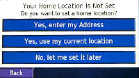
From Main Menu tap 'Where
to?' > tap 'Go Home' > 'Your Home Location Is Not Set' menu appears [If it does not then you MAY first need
to delete, from your Favorites, the current 'Home' setting] Use the first or second selection (I would use the
second under the above conditions) > tap 'Back'.
[To delete current 'Home' selection from Favorites:
From Main Menu tap 'Where to?' > Favorites
> HOME > Edit > Delete > Yes > Back(2)]
BACK-UP TECHNIQUE: 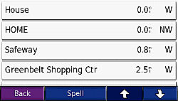
It is always wise to have a Back-up 'Home' saved in your Favorites. As a suggestion, use the identifier 'House'
or 'My Place'. Create such a Favorite using the vehicle parking location or your address.
WHY?
Suppose you've been out of town using your nüvi in a rental car and you have  changed your real 'Home' for a temporary 'Home', maybe
your motel in Schenectady, NY. There is a good reason to do this which I will explain in a later* writing. changed your real 'Home' for a temporary 'Home', maybe
your motel in Schenectady, NY. There is a good reason to do this which I will explain in a later* writing.
[*See:
WHEN YOUR HOME IS NOT YOUR
HOME
- Using a Temporary Home]
You arrive back at your home city airport and are shuttled
to a parking lot which is not so easy to find in the dark. To return to your house you CAN'T use 'Go Home' because
you have set your 'Home' temporarily to that NY motel, but you can quickly tap 'Favorites' and 'House' and the nüvi will route you back home accurately.
Please remember later to delete the old 'Home' (the motel one) and re-establish your actual 'Home'.


WHEN YOUR HOME IS NOT YOUR HOME
- Using a Temporary Home
As menti oned
above, if traveling you may want to change your Home to a different location -- for example that Schenectady, NY
motel mentioned above. The reason for this is that after your go about your business or tourism (there's a lot to see in Schenectady)[a nice PR phrase] each day you will want to return to your motel
and being a stranger to the area and not knowing the way tapping 'Where to?' and 'Go Home' (to your motel) is an
easy way of receiving directions from your nüvi. (*) oned
above, if traveling you may want to change your Home to a different location -- for example that Schenectady, NY
motel mentioned above. The reason for this is that after your go about your business or tourism (there's a lot to see in Schenectady)[a nice PR phrase] each day you will want to return to your motel
and being a stranger to the area and not knowing the way tapping 'Where to?' and 'Go Home' (to your motel) is an
easy way of receiving directions from your nüvi. (*)
METHOD
We will assume that you are in the parking lot of your motel. First it is necessary to delete whatever Home you
have previously established.
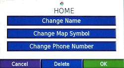
To delete current 'Home' selection from Favorites:
From Main Menu tap 'Where
to?' > Favorites > HOME > Edit > Delete > Yes > Back(2).
Now to set your new Home (the motel)
 From Main Menu tap 'Where to?' > 'Go Home' >
('Your Home Location is Not Set' screen appears) tap 'Yes, use my current location' (2nd choice on the menu)(*)
> Back. From Main Menu tap 'Where to?' > 'Go Home' >
('Your Home Location is Not Set' screen appears) tap 'Yes, use my current location' (2nd choice on the menu)(*)
> Back.
(*) You can use the address technique (1st choice on the menu) if you are not parked at your motel -- but it takes
a little longer.
DON'T FORGET, when you return back to your 'real' home, to delete the 'motel' home and re-establish your domicile
as your home using the same above technique.
HOME TO CHICAGO
- Getting There is Half the Fun

By Road:
Let's say you are planning a trip to Chicago in or on your c ar or motorcycle to celebrate February 14th. You might even park your car in a
garage at 2122 N. Clark St. ar or motorcycle to celebrate February 14th. You might even park your car in a
garage at 2122 N. Clark St.
Nothing new here. This is how you probably have set up your nüvi 650, 7/8X5T (or other models.) With machine
gun quickness and accuracy your road route is plotted by your GPS.
But you could have also decided to walk, bike, take a truck or bus and emergency vehicle or a taxi. The nüvi
gives you these other choices (which you may not use very often) in a Preference menu titled 'Vehicle.' To reach
it to make any necessary changes:

From the Main Menu tap the Wrench >
Navigation > Vehicle Bar > Choose from the list > OK > Back (2).
|

|
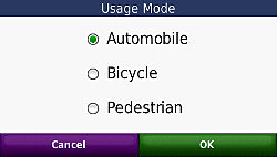
From the Main Menu tap the Tools >
Settings > System > Useage Mode - the
7X5T only permits Automobile, Bicycle & Pedestrian > Choose from the list > OK > Back (3)
|
Off-Road or Straight Line
Perhaps a more usef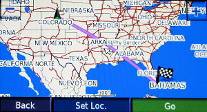 ul setting that you might want to toggle on from time to time is the 'Off-Road' setting. It will come
in useful when determining straight line or air miles or when you have to go through areas where roads are not
marked on the Garmin map -- or there are no roads at all. (See associated discussion in articles including 'CAR 54', 'GOING
STRAIGHT', 'FISHING HOLE', ETC. ul setting that you might want to toggle on from time to time is the 'Off-Road' setting. It will come
in useful when determining straight line or air miles or when you have to go through areas where roads are not
marked on the Garmin map -- or there are no roads at all. (See associated discussion in articles including 'CAR 54', 'GOING
STRAIGHT', 'FISHING HOLE', ETC.
[The above photo shows a Denver to Miami Off-Road line.
Notice that the line crosses over water.]
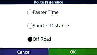
METHOD:
From Main Menu tap Wrench > Navigation
> Route Preference > Off Road > OK > Back (2).
|
|
From Main Menu tap Tools > Settings >
Navigation > Route Preference > Off Road > OK > Back (3) |
OK -- let's use it. You have already set your route from
home to Chicago in your nüvi 650/7X5T GPS. You have seen the wiggly road route. Now switch to 'Off-Road' via
the above method and notice the straight line from your house to Chicago. The line may pass  over mountains, or bodies of water -- no
matter. over mountains, or bodies of water -- no
matter.
Realistically, you might use the technique of Off-Road for short distances with your 'vehicle' GPS or to determine
the straight line mileage (not quite; discussed
elsewhere; 'GOING STRAIGHT')
between two places. Geocachers and boaters use Off-Road settings for their purposes. Many of those people have
other types of GPS units better suited to their needs
Remember, when you are through with the Off-Road setting, return to your On-Road setting of 'Faster Time' or 'Shortest
Distance'
METHOD:
From Main Menu > Wrench > Navigation
> Route Preference - (you choose) > OK > Back (2).
|
|
From Main Menu tap Tools > Settings >
Navigation > Route Preference - (you choose) > OK > Back (3) |
If you don't, your GPS will not navigate the roads
until you do.
DO YOU KNOW THE WAY TO SAN JOSE -- FROM CHICAGO?
- From Where You're Not to Another Place You're Not
You might find this technique useful some time. It is slightly
tricky because, during the process, you are going to 'NOT do somet hing you are supposed to do.' hing you are supposed to do.'
Suppose you live in Atlanta, Georgia. We won't give out your address for we don't want you to receive tons of new
junk mail. All of a sudden you get this idea to fly to Chicago's O'Hare Airport and rent a car and drive to the
San Jose Museum of Art, San Jose, California. Why? Because
you are a wild and crazy guy, you've heard
that driving West from Chicago in the middle of Winter is a relaxing experience -- not to be missed, and you do
these sorts of things all the time.
But first you want two things:
(1) to see the Garmin road route from Chicago's O'Hare Airport
(not Atlanta) to the San Jose Museum of Art.
(2) Find the estimated road mileage and duration of that trip
[IMPORTANT: Keep your nüvi 650 antenna DOWN throughout this entire procedure.]
[By the Way -- if you are
using a GPS that doesn't have an antenna that you flip up and down, for example -- the nüvi 250W (and many
more) -- using the built in software to turn your GPS 'Off' accomplishes the same thing as flipping your antenna
down. The 'Off' doesn't refer to cutting power to the unit, it just means that your unit is not looking at the
satellites and the satellites are not influencing where the GPS thinks it is.]
First, make Chicago O'Hare International Airport
a 'Favorite.'
From the Main Menu tap 'Where
to?' > Near > A Different City > OK > Enter 'CHICAGO' > Done > select Chicago, IL > Food,
Lodging > Down Arrow > Transit > Air Transportation > Air Transportation (you may have to wait a while
during the search) > Down Arrow > Any one of the 'Chicago O'Hare International' listings > Save > OK
> Back (5) (or just hold it down till Main Menu)
Second, make the San Jose Museum of Art a 'Favorite.'
From Main Menu: tap 'Where
to?' > Near > A Different City > OK > Enter 'SAN JOSE' > Done > Down Arrow (2) (scrolling down)
> select 'San Jose, CA' > Food, Lodging > Down Arrow > Attractions > Down Arrow > Museum/Historical
> 'San Jose Museum of Art' > Save > OK > Back (5) (or just hold it down till Main Menu)
Sorry about all that -- but that's the way your Garmin works
in order to set those two points as Favorites. There are a couple of other ways to set them, including if you knew
the exact address, browsing a map a nd zooming in -- but for this example let' s use the above. nd zooming in -- but for this example let' s use the above.
The next bit of skullduggery you want to accomplish is to start your road trip at O'Hare, NOT your home in Georgia. This means that you have to set O'Hare via a 'Set Loc' (set location.) This may be done by...
| [ Note: (March 2011) With some of the newer nüvis, the
white arrow, that you will read about below, has been eliminated. On these models you simply touch the screen at
the 'on the road' position that you want, and a description balloon will usually appear (but sometimes it wont).
Once you have activated a balloon, if you desire to transport your vehicle to that spot, you press the Edit (3
bars, upper left corner of the screen) and select 'Set Location'. ] |
|
From Main Menu: tap 'Where
to?' > Favorites > Spell > start typing OHARE > select 'Chicago O'Hare International' when it app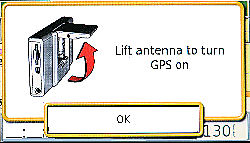 ears > GO > IGNORE
THE MESSAGE LIFT ANTENNA TO TURN GPS ON
and press OK > Zoom out quite a bit (especially if you are far from Chicago) via the '-' in the upper left corner
of the screen > Gently Touch and Drag the Screen till the checkered 'Home Flag' and the small white arrow in
the middle of the screen are in the same place (for the technical, 'are concordant') > Zoom in almost all the
way using the '+' in the upper right corner o ears > GO > IGNORE
THE MESSAGE LIFT ANTENNA TO TURN GPS ON
and press OK > Zoom out quite a bit (especially if you are far from Chicago) via the '-' in the upper left corner
of the screen > Gently Touch and Drag the Screen till the checkered 'Home Flag' and the small white arrow in
the middle of the screen are in the same place (for the technical, 'are concordant') > Zoom in almost all the
way using the '+' in the upper right corner o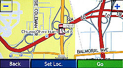 f the screen. You may have to adjust the screen along
the way to keep the flag and arrow at the same point. > When satisfied that they are, Press 'Set Loc.' Your Garmin now thinks it is at O'Hare. > Back. Remember your antenna is down, your looking
for satellites is off (otherwise it will think you are still in Georgia) and your car or car marker now appears
at O'Hare. f the screen. You may have to adjust the screen along
the way to keep the flag and arrow at the same point. > When satisfied that they are, Press 'Set Loc.' Your Garmin now thinks it is at O'Hare. > Back. Remember your antenna is down, your looking
for satellites is off (otherwise it will think you are still in Georgia) and your car or car marker now appears
at O'Hare.
[Other series units (without flip-up antennas)
might try this. First set your unit in Simulation Mode. Then find your Favorite (Chicago O'Hare ...)(you've already
established this.) Don't press 'Go' but press 'Map' or 'Show Map' instead. Press 'Set Loc.' at the bottom of the
screen. The location of your car marker has changed to O'Hare.]
Almost done.
Press the Menu button and
press Stop. This will erase that Georgia
to O'Hare road track, which you don't need.
Now let's put in your art museum destination.
[Remember, at this point your GPS thinks that it is at O'Hare]
From the Main Menu: tap 'Where
to?' > Favorites > Spell > type 'SAN JOSE' > select or scroll to select 'San Jose Museum of Art' >
GO > IGNORE THE MESSAGE LIFT ANTENNA TO TURN GPS ON and press OK a map containing the route with a starting
point at O'Hare and an ending point at the art museum appears. By Zooming out you can see it better and study where
you are going to be driving.
Let's find out how many road miles it will be and the
estimated time to drive.
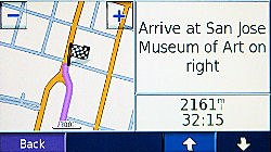
Tap the 'Turn In' at the Map
Screen (lower right side) > Hold down the Down Arrow until it can scroll no more > Read the estimated trip mileage and the trip time. Tap the Back button and you will return to your
road map.
Added March 28, 2008
Reader Robert Lazar reports that on his nüvi 780
the technique is a little different [from the 650] and suggests that 780 owners (and maybe other in the 700 series)
do this:
Tap on the full turns list (top center
of Map Screen). When the list comes up, hit "Show Map". Then on the bottom right of the screen the nüvi
780 will tell you how long (how much time) it will take to get to your final destination total time left). It also
shows you the total distance left to go in miles.
Thanks Robert!
Note: It doesn't work with my nüvi 650.
[August 20, 2008, Steven S., Ontario, Canada
states that the above technique works with his nüvi 250W]
Let's review what you did:
- You made two points of interest 'Favorites'
- You turned your GPS satellite 'looking' capability off
by keeping your antenna down -- or
putting it in 'Simulation Mode'
- You made your GPS think it was in a location it wasn't
(via 'Set Loc.')
- Your GPS mapped out a road route from where it wasn't to where you want to go
- You determined the road mileage for that trip
- [2161 miles]
- You determined the estimated time it would take you to
make the drive. [30+ hours]
- You were able to study your route while you were still
back in Georgia enjoying your peach and peanut pie.
Now, when you fly into Chicago all you have to do is to rent a car, tell your GPS to take you to the San Jose Museum
of Art (it's in your Favorites) and be on your way.
NOTE: To remove your 'Set Loc.' either pull your antenna up (650) or turn your unit off via the button
on top. Also, 'Stop' your route at the Main Menu. For other units that you have set in the Simulation Mode, you can just switch back
to Normal Mode.
[PS: There are other ways of doing this on your
Garmin nüvi 650, but for now -- this is enough. If I were at home, I would go to http://maps.google.com and get this information much quicker on my computer. But of course, I'm not a wild and crazy guy
-- like you.]
 (HEAR:
30 sec snippet "Do you know the way to San Jose") (HEAR:
30 sec snippet "Do you know the way to San Jose")
[music revised November 16, 2008]
CAR 54, WHERE ARE YOU?
- Finding my car at the Shopping Mall/Stadium/Disneyland/Airports/Mustang
Ranch
see end of article
I'm always losing my car for a while at the bigger parking
 lots, especially if
the aisles or sections are not clearly marked with numbers, letters, colors or pictures of cute animals. Invariably
two big gas guzzling SUVs park on either side of my petite Lamborghini Murciélago R-GT, hiding it from view
making it impossible to find. And besides, the parking lot always looks unfamiliar approaching it from a different
angle. lots, especially if
the aisles or sections are not clearly marked with numbers, letters, colors or pictures of cute animals. Invariably
two big gas guzzling SUVs park on either side of my petite Lamborghini Murciélago R-GT, hiding it from view
making it impossible to find. And besides, the parking lot always looks unfamiliar approaching it from a different
angle.

In the past, I tried my car key safety button but that doesn't have the necessary distance response and I have
to be right on top of my car before it works. I've even installed a separate pocket activated 'car finder' that
honks the horn at the touch of a button. But that too doesn't have the range and it is hard to hear the sound of
the melodic Italian horn in a noisy USA NASCAR parking area.
SOLUTION: I now use my nüvi to find my parked car.
Upon parking, I tap the auto
on the Map Screen > tap 'Save' > edit On Screen Keyboard to read 'A' (a short name) > tap 'Done' >
tap 'OK' - to save to favorite locations > turn my nüvi off and put it in my pocket.
Upon leaving the location to find my 'veicolo' (Italian for vehicle) I activate my nüvi 650, AND THIS IS IMPORTANT -- SWITCH TO OFF ROAD (which allows
straight line travel.)
From Main Menu tap Wrench
> Navigation > Route Preference > Off Road > OK > Back (2) > Where To? > Favorites > 'A'
(which should be at top) > Go!
I switch to maximum 'zoom in' by holding the '+' down and closely follow the straight line to my automobile.
If you follow this method you will get to your car. Please don't walk over the tops of other parked cars
or into ditches and buildings.
Also see 'In The City' comment in yellow
box below.
ADDITIONAL TIP: (I'm still working on this so
I am not sure) You may find that turning your
WAAS/EGNOS ON may help you be more accurate.
METHOD: Main Menu
> Wrench > System > WAAS/EGNOS -- turn On > OK > Back (2).
Remember also, when you get to your car, change your OFF ROAD setting back to 'Faster Time' or 'Shortest
Distance'.
METHOD: Main Menu >
Wrench > Navigation > Route Preference > (you choose -- I like Fastest Time) > OK > Back (2).
If you don't, your GPS will not navigate the roads
until you do.

IF YOUR NÜVI HAS A CAR LOCATOR
FEATURE
I believe that in some of the newer model nüvis, starting
with the 700 series, a Car Locator feature is included. When you remove the unit from
it's cradle it sets a 'Last Position' in your Favorites area. Now all you have to do upon exiting the stadium/shopping
mall etc. is set your unit (look in Navigation > Route Preference) to 'off-road' and choose the 'Last Position'
from your Favorites list. A straight line track will be presented to you.
Perhaps you are in the city, blocks away from your car, then it is recommended that you set your nüvi to Pedestrian
Mode (rather than off-road)(Look in Navigation> Vehicle) and you will be guided in a sensible walking way to
your car along sidewalks.
Remember to re-set your nüvi back to where it was (possibly) -- Car/Motorcycle and Faster Time or Shorter
Distance before you drive away. |
|
|
The 7/8X5T series provides a 'Last Position'
setting each time you remove your unit from its cradle (while the power is on.) When you are ready to return to
your vehicle just select 'Where To?, from the main menu > select 'Favorites' > select 'All Favorites' >
select 'Last Position'. Navigation back to your vehicle will automatically be 'Off Road' straight line. Once you
arrive and either establish another destination or stop any route, you will be back in your normal driving settings. |
(HEAR: Car 54 Theme - 1:08)
GOING STRAIGHT
- Off-road/On-road mileage
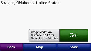
Just suppose you wanted to find out how far it is from where your GPS is now and Straight, Oklahoma [a small town
in the OK pan handle betwee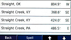 n Kansas and Texas. (lat. N 36.86384; long. W 101.42389)] With a GPS like the nüvi 650, from the
menu you could n Kansas and Texas. (lat. N 36.86384; long. W 101.42389)] With a GPS like the nüvi 650, from the
menu you could
tap 'Where to?' > Cities > Spell
> type 'Straight' > Done > Straight, OK [PLEASE NOTICE THE MILEAGE LISTED THERE] > Go!
and a road map will be drawn to your destination.
|
|
Tap 'Where to?' > Down > Cities
> Spell > type 'Straight' > Done > Straight, OK [PLEASE NOTICE THE MILEAGE LISTED THERE]. A small window will 'eventually' slide out from under the Go button and reveal
the road distance (different from the straight line distance I had you look at) and the estimated driving time
for completing the trip. This information appears earlier than doing the 650 instructions that follow this box.
|
BUT...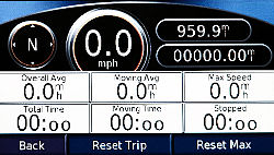
Now tap the Arrival (lower left box on your nüvi 650) and a new screen opens --
this screen is called the Trip Information
Page. Notice the oval in the top right corner
of the screen. This mileage represents the 'actual
road miles' NOTICE THAT IT IS DIFFERENT FROM THE MILEAGE THAT YOU SAW IN THE PARAGRAPH ABOVE.
CONCLUSION...

The mileage to a city that appears listed on the Cities
page is the STRAIGHT LINE MILEAGE (OFF-ROAD)
while the mileage listed on the Trip Information
Page is the ON-ROAD mileage.
The straight line mileage will be smaller than the on-road mileage (remember: "shortest distance between two
points") if you are NOT in an OFF-ROAD setting (an off-road setting is always a straight line and ergo --
the shortest distance(*).)
You can verify this by switching your settings to OFF-ROAD (method discussed elsewhere.) Now the mileage in both
cases will be the same.
Straight line mileage is handy when you want know air distance between cities or over water distance, but I am
mostly interested in road mileage. So don't be confused when you first see the mileage listed on the city page
-- IT IS NOT THE ACTUAL ROAD MILEAGE.
[(*) having said that -- it is not quite true;
for we are measuring a line on the surface of a globe (earth) in 2D and there IS actually a slight curve. But for
practical purposes we will say that for our driving purposes (relatively short distances) -- a straight line is
a straight line (even though it is part of a great circle arc.) For an involved technical discussion see:
http://www.gis.psu.edu/projection/chapter9.html ]
I NOTICED that in the above listing of cities screen
(beginning of article) that there are two entries for Straight Creek, KY -- one at 368.6 miles and one at 424 miles.
I'm thinking that unless that city has a split personality and is in two pieces some 59 miles apart -- something's
crooked in Straight Creek..
LONGITUDE/LATITUDE
- Convention
The convention that I use on my nüvi 650 for longitude
and latitude 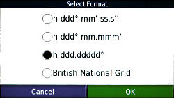 is
'degrees-decimal' [h ddd.ddddd°](*) (minutes
are represented as a decimal part of a whole degree.)
It is the third selection on the Select Format screen. is
'degrees-decimal' [h ddd.ddddd°](*) (minutes
are represented as a decimal part of a whole degree.)
It is the third selection on the Select Format screen.
From menu tap 'Where to?' > Down Arrow
> Coordinates > Format > 'h ddd.ddddd°' > OK > Back(2). 
Apply the format once and you basically can
leave it alone. I find that this format/convention works with the map conventions I use and is the easiest and
quickest for me to enter into my nüvi. Google Maps, which I will mention later**, uses this convention.
[**See:
ARE YOU COORDINATED?
- Obtaining and Using Coordinates in Your GPS]
I believe that many geocachers also use this format. At
the moment, I don't geocache but I might look into it for fun.
I will use this convention in later topics here, and show you how easy they are to obtain.
(*)[From: http://www.louisiana-fishing.org/
"Degrees may be defined as Decimal Degrees,
which will be indicated as H, DDD.ddddd, with the H meaning hemisphere, the three capital D's meaning whole degrees
and the lower case d's (.ddddd) meaning a decimal part of a whole degree. So in a position stated in H, DDD.ddddd,
the position would be in whole degrees and hundred thousandths of a degree."]

|